Showing posts with label Cheverie. Show all posts

Saturday, September 12, 2020

116 kilometres

 116 kilometres isn't really that far.  It's 72 miles.  Sometimes we express distance as time.  "How far is it to Burntcoat Head?" you ask.  "Well from my place it's around an hour and 20 minutes."

But it's not quite a direct route.  It could be.  But with me it rarely is.

I wanted to show my friend Donna, Burntcoat Head, sight of the highest tides in the world, but as usual there were places to stop along the way.

We agreed to meet up at the lay-by at Cheverie at 11:30; three hours before low tide.  There's a large parking area so you can enjoy the stunning view across the Bay of Fundy to the cliffs of Blomidon.


I've told you about this spot before.  I may have mentioned that many visitors come to take in this view, and then happily leave, not realizing they have missed something very special.

If they tore their eyes from this view and turned around they would have seen this on the hill behind them.


It's a stunning building created in 2012 by some students of Dalhousie University.  It stands atop a grassy hill, just waiting to be explored.  But few people even notice it.


To be fair, it's not like there is a large sign or anything.  
This teeny sign is the only thing directing you to it.


In a dark room within those walls is an enchanting surprise.  Well not at first.  You have to wait a bit for your eyes to get used to the darkness.  Then you simply stare at the floor waiting and waiting ... until on the floor you see projected the view across the Bay.  What's super fun is when a car zips by at your feet.  (The smudges and marks I think reside on the mirror that projects the image)


BTW that's Donna's car parked just left of centre.  The road is just behind it. Below, is what the projection is showing.

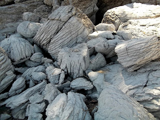
Just a kilometre down the road we turned down Shipyard Road so I could show Donna the gypsum cliff.


After a walk there we continued on to Walton where we got take-out lunch at the Walton Pub -- "Under one billion served" it declares proudly on their sign.


We ate it at the Walton lighthouse.


It was pretty close to low tide.


We stopped on our way back home several hours later for a comparative photo.


Finally it was time to head to Burntcoat Head.


Did I mention that we brought our dogs with us ?


Donna has a black and a white Schnauzer; Pyper and Allie.


We just about had the whole shore to ourselves.  We walked for a while and wanted to keep walking but as I kept reminding Donna, "the tide has turned".


Donna's high tech watch told us that we'd walked 10,000 steps.  I was pretty darn tired by the end of our explorations and easily believed we'd walked that and then some.

The dogs were pretty tired too.


Thursday, April 18, 2013

OMG, OMG, OMG ! (insert squeal of delight here)


This is what I posted on my FaceBook status* update on Sunday:


"OMG, OMG, OMG, OMG, OMG.

Out with my friends Amy and Mickie today.  Mickie said she needed to run into Tim Hortons to get a gift certificate. got inside, Mickie was looking at a map and giving someone directions.  Mickie asked if I could help give the lady directions to the Bay of Fundy.  I wandered over.  The lady said it was her friend at the table who needed to be shown the map.  I turned.  The friend at the table pushes the hood back on her coat ... and ... it's my friend SANDY !   Sandy from Ontario !   Sandy from Ontario is standing there in front of me !  I must have stood there with my hand over my mouth for a full 30 seconds.    

OMG, Sandy is here !   She and her friend Gail left Ontario Saturday at 7 pm, arriving in Halifax around 3 pm on Sunday.  They'd driven straight through !

May I repeat OMG, OMG, OMG ! "


~~~~~~~~~~~~~

Question:  What do you do when a friend drives 1,700 km. to surprise you with a visit ?

Answer:   You show her the best time you can.

You take her over to the Bay of Fundy,
to see the Gypsum cliffs at Cheverie.


Then you continue on to the wonderful red cliffs of Burncoat Head.


Then you take her for a sun-drenched walk along the trails of Shubie dog park.


Today we went clamming with her friend Gail, on Three Fathom Harbour at low tide. 


Two more days before she has to head back.

Wonder what we should do next ?

~~~~~~~~~~~~~~~~

* Please forgive my over-use of exclamation marks but ...     OMG Sandy is here !

Thursday, February 7, 2013

Frigid Fundy .


Yesterday Lynne and I, with Wendy and Trey in tow, went to see how the Bay of Fundy is dealing with this bitter winter.

Normally when you go to visit a place you check to make sure you know where you're going and what the weather will be like.  When you visit Fundy, you must also take into account one other very significant factor -- the tides.

Here's a what a tide table looks like.  In the sample below you can see that HIGH tide was at 4.26 a.m. and peaked at 13.6 m or 44.6 ft.  YES, 44.6 FEET !   Low tide was at 10:51 a.m. at 1.9 m or 6.2 ft.


The high and the low tides do not occur at the same time each day.  They advance around the clock by about 50 minutes each day.   Note too, that there are two high and two low tides each day.  It takes the tide about six hours to go out and then six hours to come in, then six hours to go out, well you get the picture.

The tides on the Bay of Fundy are the highest tides on the planet.  The 100 billion tonnes water flowing in and out of the Bay of Fundy is greater than all the water in all the freshwater rivers on Earth !  


As you can see from the image below, Fundy is wider at its mouth and gets narrower towards the top. What you can't see is that its bottom likewise goes from deeper to shallower.  Now, imagine lifting up one end of a bathtub with six inches of water in it.  The tub is shallower and narrower at the far end.  As you tip it, the water gets far deeper than the six inches it started at.  Fundy's like that bathtub.  Neat eh ?


As we were headed for Burn(t)coat Head (no one can agree on the spelling), the site of the highest recorded tides in the world, it was important to know where we were in the tide cycle.  Can you guess where Burncoat Head would be located on this map ?

Here is an image of Fundy at low tide in the summer.  No water in sight.  Six hours later, at high tide, the water would be reaching into the foreground area.


So what did Lynne and I find at low tide yesterday ?


The ice that formed at high tide was left behind when the water underneath it receded.


My plans for Lynne and I to walk the shore at low tide, were quickly dashed.

Gypsum cliff at Cheverie.

With a few exceptions the shore was impassible.  We consoled ourselves with getting as close as we could, and taking lots of photos.

Lynne freezing her hands to take photos.

Trey on the ice.

With their built-in, claw-grippers, the dogs walked safely on top of the slushy tops of the ice blocks.  As the tide was out, there was no water below them.

Wendy with the gypsum cliff at Cheverie.


The same little island at Burncoat Head at low tide in summer and winter.


I am not liking this colder than usual winter, but I must confess that it has created some incredibly beautiful scenes.